Build Real-Time Location Apps with Mapify
February 20, 2025
Nuri Shahzad

In a world where location intelligence is becoming a critical asset for businesses, government agencies, and technology-driven industries, Mapify provides a flexible platform for building real-time geospatial applications without requiring extensive coding knowledge.
Organizations that need to process, visualize, and act on geospatial data in real time can use Mapify to create interactive maps, automate workflows, and build location-based applications that streamline operations and decision-making.
This article explores the many ways you can leverage Mapify, from real-time tracking and logistics management to business intelligence, asset monitoring, and workflow automation.
Building Live Maps with Real-Time Data
Interactive real-time maps allow businesses and organizations to track critical assets, monitor events, and gain insights from dynamic data. Whether it’s monitoring environmental conditions, tracking vehicle movement, or analyzing foot traffic patterns, Mapify makes it easy to visualize data as it changes.
You Can:
- Integrate real-time data from IoT sensors, GPS trackers, and public APIs.
- Create custom map layers to display geospatial data in an interactive format.
- Set up dynamic filters to refine and analyze location-based information.
- Automate data updates so maps stay current without manual intervention.
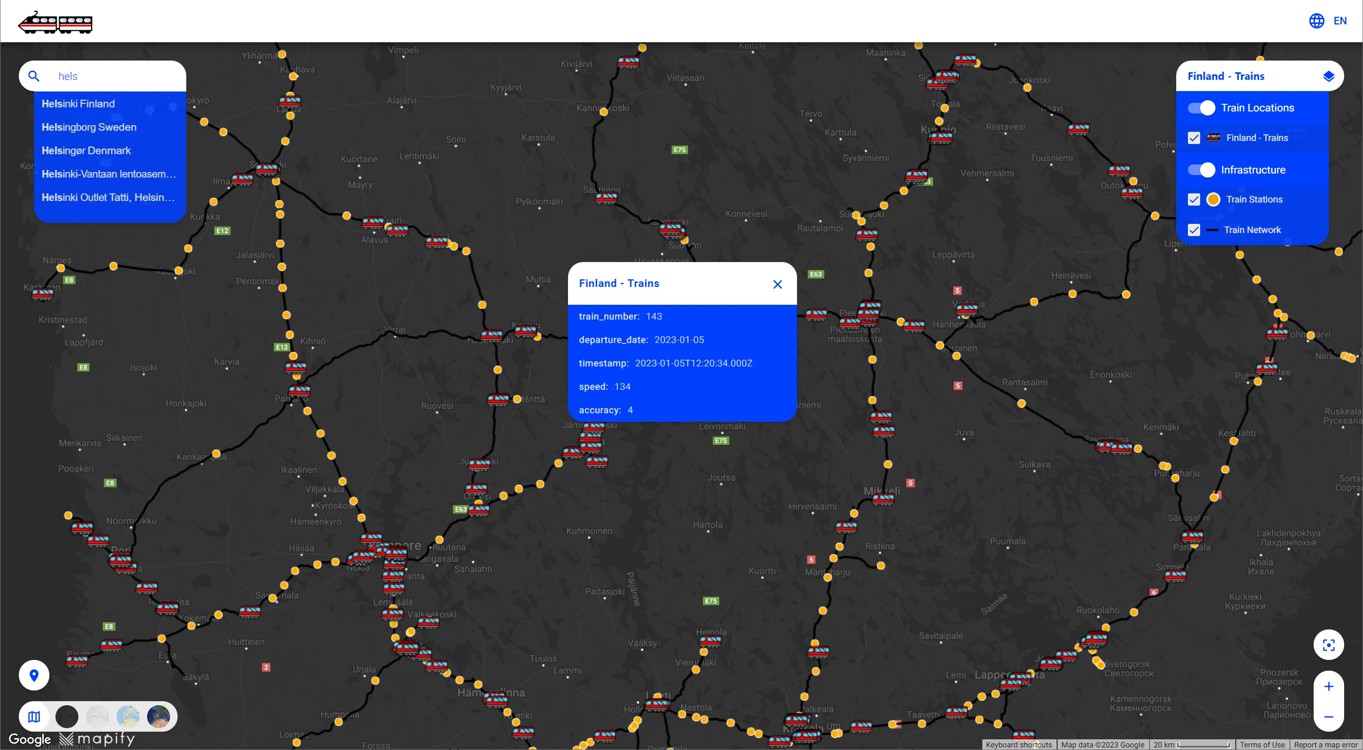
For instance, Helsinki offers one of the most advanced open data ecosystems, and with Mapify, this data can be transformed into real-time insights. The city’s transportation department can track public transit routes, monitor road conditions, and analyze traffic flow using real-time mapping.
Watch here how Helsinki's open data is used in real-time:
Tracking and Managing Moving Assets
Businesses that rely on logistics, transportation, or supply chain management need real-time visibility into the movement of their assets. With our platform, organizations can track vehicles, deliveries, and personnel, ensuring that operations run smoothly and efficiently.
You Can:
- Monitor vehicle locations in real time with GPS-based tracking.
- Automate alerts for delays, route deviations, or unexpected stops.
- Optimize delivery and transportation routes based on real-time data.
- Generate reports for analyzing historical movements and performance trends.
Logistics companies can use our platform to gain real-time insights into their vehicle fleets by tracking data such as latitude, longitude, speed, and many other parameters, all displayed on an interactive map. Beyond location tracking, Mapify integrates additional sensor data, enabling the monitoring of cargo conditions such as temperature and weight distribution. This comprehensive approach improves fleet management and allows for proactive issue resolution, enhancing operational efficiency and customer satisfaction. For a deeper understanding, read more about building a no-code geofencing solution in this article: Real-Time Vehicle and Cargo Tracking Using Mapify.
Setting Up Location-Based Triggers and Alerts
Mapify allows businesses to automate location-based actions using geofencing and workflow triggers. By defining geographic boundaries, organizations can trigger alerts, automate responses, or log events when an asset enters or leaves a designated area.
You Can:
- Set up geofences around warehouses, delivery zones, or restricted areas.
- Trigger notifications when an asset enters or exits a predefined zone.
- Automate operational tasks based on location data.
Watch this use case to learn how Mapify’s geofencing feature sets up two restricted areas, simulates a vehicle’s route, and triggers an automatic email alert when the vehicle enters a restricted zone.
Creating and Sharing Interactive Maps
Organizations that need to communicate geospatial data to stakeholders or the public can use Mapify to build and share interactive maps. These maps can serve as decision-making tools, public information portals, or internal dashboards for real-time monitoring.
You Can:
- Build web-based maps with customized layers, filters, and styling.
- Share maps with teams, clients, or the public through secure access settings.
- Embed interactive maps into websites or business applications.
Want to learn how to customize your Mapify app? This step-by-step guide shows you how to personalize your app by setting up a custom icon, cover image, header image, and selecting colors. Whether you’re matching your company’s branding or creating a unique look, this tutorial makes the process simple.
A city council can use Mapify to publish a live map showing emergency shelters, safe evacuation routes, and active fire zones during a wildfire. Residents can access real-time updates on shelter availability, road closures, and fire progression, helping them make informed decisions and evacuate safely.
Mapify makes it easy for businesses, municipalities, and organizations to manage geospatial data without the need for complex coding.
Whether it's tracking assets, automating processes, or sharing real-time information, the platform provides a simple, no-code solution that adapts to different needs. Sign up for a free trial at mapify.ai/trial.